One Network step-by-step instructions
Step 1
Find the location of the works you wish to check using our resurfacing and surface dressing pages.
You can also find a location by entering a street name, parish, ward, district or local authority in the 'Where do you want to go?' box, or by USRN or works reference number.
Step 2
Copy the USRN for that specific scheme and paste into 'Search Locations'. You can also use longitude/latitude coordinates should you have them to hand.
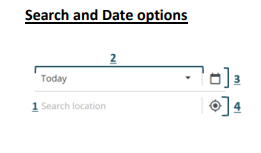
Search and date options
- Search by location, date, works ref, USRN, plan ID or longitude/latitude
- Date ranges include today, next two weeks, next three months, next year
- There's also a calendar date picker to allow you to choose specific date ranges
- Geolocation allows the map to identify your current location
Step 3
Click on the 'Today' button for a dropdown list. Select a suitable date range.
Step 4
 Ensure that the correct layers are on by clicking the icon in the top left corner of the interactive map.
Click on the arrow to the right of each tab to see which layers within can be activated or deactivated.
A layer is activated when there is a tick in the box. Some layers are only visible at certain levels of zoom.
Step 5
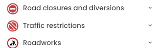 To find planned road closures and diversions that affect the area in question, please click on and select 'Toggle all' for road closures, diversions and traffic restrictions or 'Road Works'.
Step 6
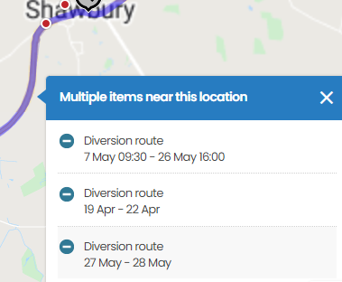
Zoom in and click on the line for the location in question.
Road closures and diversion layers will present as lines along affected roads, accompanied by icons.
Lines are only visible at certain levels of zoom, depending on their length. Clicking on these lines or icons will reveal detailed information about the closures and diversions, such as times in force, a description of the disruption, diversion directions, and attached documents (see below for more information on what the icons mean).
Step 7
Clicking onto the line will present any planned works that affect this route (see below).
By clicking into an entry as shown above, this will bring up a prompt box that will provide detailed information such as:
- Originator: the organisation that has put the permit in place will have their logo at the very top
- P
 lease note that there are occasions (particularly for weather dependent work programmes such as surface dressing) where a broad date range is initially indicated. Further detail on planned closure dates/times is available by clicking on the road works icon
 - Description: details on the nature of the work
- Route description: if there's a planned diversion in place, this will be detailed in this section
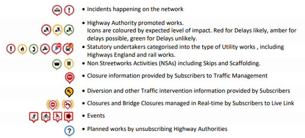
Map icons
The icons you'll see on the map indicate the following:
More detailed guidance is attached to this page. A pdf version of the information on this page is also attached.